

Walking and cycling tours
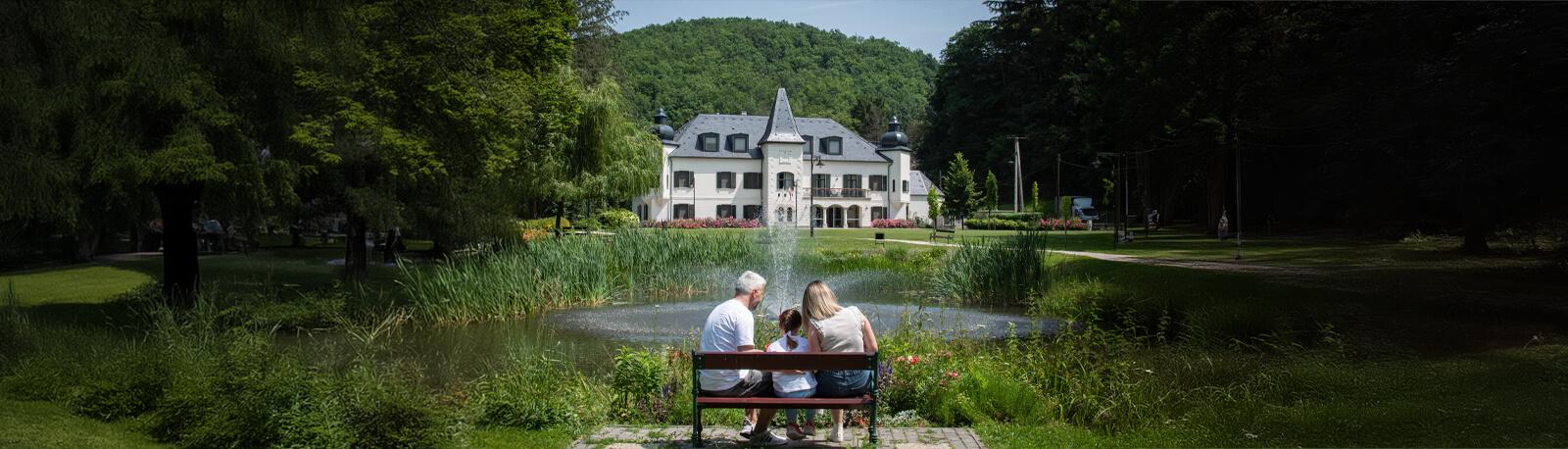
The picturesque Zemplén Landscape Protection District offers a unique experience for nature lovers. The pine-oak and beech forests of the Zemplén Mountains of volcanic origin, as well as the small clearing and meadows hidden between them are home to countless rare plants and animal species. Located in the heart of the Landscape Protection Area, the Újhuta Castle Resort is surrounded by several hiking and cycling trails, along which our guests can wander admiring nature and discover the attractions of the area. All tours start from Háromhuta (Ó-, Közép- és Újhuta).
You do not have to give up your walks in the forest because of muddier hiking conditions as our boot washing service is available in the hunting castle, so after spending pleasant minutes outdoors, you can start your next outing with clean shoes.
Walking tours
Pálos tour – Pálos forrás (spring) and és monastery ruins
Leaving Óhuta in the direction of Regéc, turn right off the paved road and then walk about 1 km to the Pálos forrás.
(monastery ruins, spring, lake)
Babuka tour – Babuka tó (lake)
Starting behind the delicatessen in Óhuta, you have to walk about 1.5 km to Babuka tó. (spring, lake, look-out, fireplace)
Czárán tour – Éles-bérc, Czárán pihenő (rest area)
From the Glassworks, we set off on the road leading between the fences of two houses in the direction of Éles-bérc. After crossing the footbridge, we continue to the left along the old forest road. After a 10-minute walk, we reach Éles-kő, below which by turning right at the upper end of a small group of pines we leave the wide road and climb up to the top of the rock. Here we continue along a well-travelled forest road, and after 5 minutes we reach Susogó tisztás. From there, after another 5 minutes of walking, you will find Czárán pihenő (rest area) on the left before the road bend. (Éles-bérc)
Tour 1:
From the centre of the village (the road under the house that preserves folk traditions) start on the forest road (no sign) to the Glassworks (junction: towards Óhuta and Középhuta) – then walk to Óhuta on the asphalt road, back to Középhuta on the asphalt road.
Level: easy
Distance: 4 km
Tour 2:
Középhuta – Újhuta, turn right at the blue square after the castle (approx. 1.2 km) – after the wooden bridge turn right on the forest road (800 m) – Zsidó rét – turn left at the blue sign and there you find Eszkála – Gerendás rét – follow the green sign to Újhuta (approx. 1 km) – Középhuta
Level: easy
Distance: 9 km
Tour 3:
Cross the wooden bridge at the Középhuta sign, then follow the yellow sign to Mlaka rét – from here follow the yellow triangle sign to Sólyombérc (nice view, rock climbing school) – follow the blue sign to István kút 1 km (protected birch forest) – follow the blue sign to Gerendás rét – blue triangle: Kerekkő (beautiful panorama) – on the green sign, touching Flórika forrás (rest area) 1 km to Újhuta – Középhuta
Level: medium
Distance: 12 km
Tour 4:
Cross the wooden bridge at the Középhuta sign, then follow the yellow sign to Mlaka rét – from here follow the yellow triangle sign to Sólyombérc (beautiful view, rock climbing school) – Mlaka rét – follow the yellow sign (through the wonderful Ördög völgy) to Kőkapu (Károlyi castle, boating lake, narrow-gauge railway) – back: on the green sign next to Komlóska stream 6 km to the blue square sign – on the blue square to Újhuta – Középhuta. (You can also get back on the asphalted forest road, or continue on the steep slope that continues to the lest of the asphalt road, following the green sign.)
Level: medium
Distance: 13 km
Tour 5: Középhuta – Regéc (shorter)
On the asphalt road until reaching Óhuta, at the end of Óhuta, next to the football field, turn left along the Red sign, the Red-Blue Trail leads up to the castle ruins.
Distance: 13 km
Tour 6: Középhuta – Regéc circular tour (longer)
To István kút it is the same as Tour 3, from István kút follow the Blue sign to Regéc, or follow the Blue sign and then take the Green sign at the Tokár tető to Regéc.
On the way, touching the Nagy-Péter Menykő kilátó (look-out point) on the blue triangle (beautiful panorama), as well as Pengő kő and Tokár tető peak, and back following the Red sign to Óhuta, then on the asphalt road to Középhuta.
Level: a little harder due to the distance
Distance: 21 km
Tour 7: Középhuta – Újhuta – Makkoshotyka – Sárospatak or Sátoraljaújhely
From Középhuta, at Újhuta on the Green sign to Gerendás rét, then along the Blue trail to Makkoshotyka touching Eszkála, Zsidó rét and Cifra kút, from there continue on the Blue trail to Sátoraljaújhely, touching Cirkáló tanya. Or by walking from Cifra kút on the blue square through Hercegkút, we arrive at Sárospatak.
Level: difficult due to distance
Distance: Sárospatak: 23 km
Distance: to Sátoraljaújhely: 32 km
Tour 8: Zemplén endurance hike
Distance: 50 km
Level rise: 1580 m
Level time: 12 hours
Start: Mogyoróska, Templom tér (Templom square)
Destination: Sátoraljaújhely, railway station
The main route: along the line of the National BLUE Trail, touching the Yellow and Red signs.
Level: It cannot be classified as a very difficult tour, there is relatively little elevation gain, it can be comfortably completed on foot in 12 hours. If someone is in good condition, trained, likes to hike, and walks on a regular basis, has willpower and endurance, then it can be done.
Bike Tours / City-bike Tours
Tour 1:
Középhuta – Glassworks – Óhuta – Regéc – Középhuta
On the asphalt road connecting the villages, with a slight ascent to Regéc.
Level: easy tour
Distance: 24 km
Tour 2:
Középhuta – Újhuta – Flórika-forrás – Gerendás rét – Kőkapu – Középhuta
The tour leads along an asphalted forest road towards the interior of Zemplén, ascending to Gerendás rét, and then descending to Kőkapu.
Level: An easy tour for regular cyclists.
Distance: 25 km
Tour 3:
Középhuta – Glassworks – Erdőhorváti – Komlóska – Középhuta
On the asphalt road connecting the villages, in a flat area, with minimal car traffic.
Level: medium tour
Distance: 30 km
Tour 4:
Középhuta – Glassworks – Erdőhorváti – Tolcsva – Erdőbénye – Középhuta
On a low-traffick route between villages, on flat terrain, with minor ascents.
Level: Easy terrain, medium
Distance: 40 km
Tour 5:
Középhuta – Újhuta – Flórika forrás – Gerendás rét – Pálháza – Filkeháza – Füzér – Füzéri Castle – Füzér – Filkeháza – Pálháza – Gerendás rét – Flórika forrás – Újhuta – Középhuta
On the asphalt road connecting the villages, with minimal car traffic, the 6 km section between Pálháza and the Füzér junction can be busy.
Level: long tour, with small and large climbs
Distance: 52 km
Tour 6:
Középhuta – Glassworks – Erdőhorváti – Tolcsva – Erdőbénye – junction at Sima – junction at Boldogkőváralja – Abaújszántó – Tállya – Mád – Disznókő (junction at Mezőzombor) – Bodrogkisfalud (4 km to the junction at Boldogkeresztúr on motorway no. 37) – Szegi (parallel to motorway no. 37 via the village) – Olaszliszka – Vámosújfalu – Tolcsva – Erdőhorváti – Glassworks – Középhuta
Railway station: Mezőzombor, Olaszliszka (bus stop as well)
Level: Difficult hike, with elevation gain, long distance, 5 km on motorway no. 37
Distance: 88 km
Bike Tours / Mountain-bike tours
Pálos tour – Pálos forrás (spring) and monastery ruins
Leaving Óhuta in the direction or Regéc, turn right off the paved road and then walk about 1 km to the spring (monastery ruins, spring, lake)
Babuka tour – Babuka tó (lake)
Starting behind the general store in Óhuta, you have to walk about 1.5 km to Babuka tó (spring, lake, lookout, fireplace)
Tour 7:
Középhuta – Újhuta – Flórika-forrás (spring) – Gerendás-rét – on the blue sign to the left to István kút – on the Yellow sign (forest road) Glassworks – Középhuta
Level: easy hike in forest terrain
Distance: approx. 12 km
Tour 8:
Középhuta – Glassworks – Óhuta – junction at Dorgó (right before Regéc, forest road closed with a barrier) - Pengő kő – Nagy Péter menykő – István kút – on the Blue sign to Gerendás rét – Flórika forrás to the right on the asphalt road – Újhuta – Középhuta
Level: forest terrains with climbs, mountain bike required
Distance: 25 km
Tour 9:
Középhuta – Újhuta – Hercegkút – Sárospatak – Középhuta
After Újhuta, we turn right at the cross, the forest tourist road marked with a Blue square leads to Hercegkút. The length of the forest road is 4 km.
Level: forest terrain, sometimes with steep inclines, requires practice and good equipment
Distance: 35 km
